UK Rainfall Comparison Tool
Rainfall Pattern Comparison
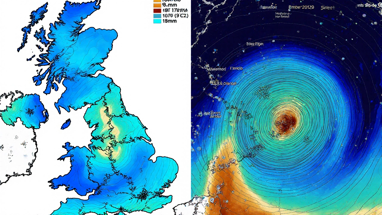
Compare expected November rainfall for different UK locations based on Met Office data. This tool demonstrates how geography influences precipitation patterns across the country.
By late November 2025, the UK is already feeling the weight of a wetter-than-average month. From London to Leeds, rain has been persistent, and while temperatures haven’t dropped into freezing territory yet, the damp chill is setting in. If you’ve been checking your phone for updates, you’ve probably seen the same warning pop up: UK weather is unsettled. But what does that really mean for your day-to-day life? And why do some apps say it’s going to rain all day while others say it’s just a drizzle?
What the Met Office Is Saying Right Now
The Met Office, the UK’s official weather service, released its latest forecast on November 28, 2025. The big takeaway? A large low-pressure system is sitting over the Atlantic, pulling moist air from the southwest straight into southern and western parts of the country. That’s why Plymouth is already seeing 136mm of rain this month - more than double what London has received (59mm). This isn’t unusual. The UK’s weather has always been split down the middle: wet in the west, drier in the east. The Met Office’s Unified Model, updated in early 2023, is running at full power. It’s processing over 230 terabytes of data every day from satellites, radars, and more than 1,500 ground stations. That’s why their 48-hour forecasts are still the most accurate in the country. But even they can’t predict every shower. Thunderstorms? Those remain a challenge. At 24 hours out, their accuracy is only about 35%. That’s why you might get a warning that doesn’t pan out.Temperatures Across the UK
There’s no big cold snap yet. Average daytime highs are hovering around 9°C in most cities. Nighttime lows are mostly between 4°C and 5°C. London’s max is 10°C, Leeds is at 8.8°C, and Sheffield is just a bit cooler at 9°C. That’s close to the 30-year average for November. But what’s unusual is how warm it feels for the time of year. The Met Office’s long-range team, led by Professor Adam Scaife, has flagged a rare event: a minor sudden stratospheric warming. It’s not common this early in November - it usually shows up in December. But when it does, it often leads to colder weather two to three weeks later. So while it’s not freezing now, December might be.Why Rainfall Varies So Much
If you live in Manchester or Sheffield, you’ve had rain on 12 out of the last 15 days. In contrast, parts of East Anglia have seen only 3 or 4 rainy days. Why? Geography. The Pennines and the Welsh mountains force moist air upward, causing it to cool and dump rain on the west. By the time that air reaches the east, it’s drier. That’s why London gets 67mm this month, but Sheffield and Manchester both get 93mm. The Met Office’s 1km resolution UKV model shows this gradient clearly - something most commercial apps don’t show. You’ll also notice that some weather apps, like Weather2Travel, say it’s going to rain 15 days this month. The Met Office says 8 to 10. That’s because they’re using different models. The Met Office uses its own Unified Model. Weather2Travel leans on the European Centre’s ECMWF data. Both are good, but for different things. The Met Office is better at wind and storm tracking. ECMWF is slightly better at predicting exact rainfall amounts near coasts.
Who Do People Trust?
Ask 1,000 UK residents who they trust for weather, and 63% will say the Met Office. That’s higher than the BBC (41%) or any app like AccuWeather or Weather25. Why? Because people know the Met Office is the source. The BBC and apps just repackage it. The Met Office also runs the official flood warning system. In a 2022 survey, 89% of people said they had enough time to prepare when a flood alert came through. That’s real value. But there’s frustration too. On Reddit’s r/UKweather, users complain about “too many rain warnings that never happen.” That’s because the system is designed to be cautious. A 30% chance of rain? They’ll still flag it. Better to warn than to miss a downpour that floods a road. Still, it’s annoying when you’re planning a picnic.How Businesses Use the Forecast
This isn’t just about umbrellas. The UK economy runs on weather data. National Grid uses temperature forecasts to predict electricity demand. When it’s cold, people turn up the heating. When it’s wet, they stay inside. That’s why they can predict 92% of daily usage changes just from a 5-day forecast. Supermarkets like Tesco adjust their fresh produce orders based on 72-hour rain predictions. If it’s going to rain for three days, they order fewer salads - people won’t buy them if they’re stuck at home. That one change cut food waste by 18% in 2022. Even farmers rely on it. The Met Office’s agricultural service gives crop-specific forecasts down to the county level. That’s how they know when to spray pesticides or harvest.


